February 4, 2022:
Pirates Cove Resort, Stuart Florida.
How did we get to Stuart
from Venice last Saturday? Well, here’s a recap:
Saturday
January 28, 2023, Travel Day # 95 Crow’s Nest Marina, Venice FL. To Cabbage Key
Inn, Cabbage Key Fl. Distance 45 Miles,
Total Time 6 Hours, We
had spent 2 nights in Venice at Crow’s Nest Marina where we published our last
update on the blog. We were able to spend a night with Bob and Barbra Keller at
their winter home. Bob and I played a
fun round of golf the next morning, then they dropped us off at the boat. We left the marina just after 8 AM as we had
a 45-mile day. On the first leg of the journey, we had to cross Roberts Bay a
fairly wide body of water. The majority of the day’s trip was going to be in a narrow canal, a high bank land cut
that was created to keep the GIWW (Gulf Intracoastal Waterway) passable. So,
navigation was very easy and we had two bridges that we had to ask to be raised.
One was on the hour and ½ hour the second was on demand. We slowed down for the
first bridge opening for 3 miles, so we didn’t have to hang out at the bridge
and avoid any backups. The landscape was boring and there were very few house
and no industry. This is a rural part of the GIWW, so we didn’t take a lot of
pictures. The last 15 miles was in the Gasparilla Sound and Boca Grande. Lots
of beautiful homes in that are and I do have some pictures of them. It was a
sunny day and we had very little boat traffic, until we got to Charlotte
Harbor. A very pleasant day to cruise.
Cabbage
Key Inn is located 4 miles south of the landfall of Hurricane Ian, which was at
at Cayo Costa. Cabbage Key Inn is
located on a private Key, which is owned by a family who have done an amazing
job getting the operation back up and running. They have a construction crew of
25 workers living on the Island and they work 6 days a week from sunrise to
sunset. These folks worked their tails off, it was amazing to see the progress
they have made. Cayo Costa is a disaster area still, no progress was made there.
The construction crew leaves for the mainland / home Saturday night and return
to the Key on Monday morning. We happened to be there when they were going off Cabbage
Key for their one day off. One group of happy workers I can assure you.
They
have replaced all the docks and were working on getting the cottages and hotel
rooms open. They have a great restaurant that was very open and popular on their
property, and we had dinner there. They also house 40 employees that run the
marina, the restaurant, and the hotel. They do a huge lunch business, (there must
have had 40 boats visit between 1 and 4PM and have lunch at the restaurant). Many
local folks come by boat from Venice, Englewood, and Fort Myers. We enjoyed our time there; it was a great atmosphere
and a fantastic meal at the Inn.
Sunday,
January 29,2023 Travel Day #96 Cabbage Key Inn, Cabbage Key FL. to Sweetwater
Landing Marina, North Fort Myers FL. Total Distance 46 Miles, Total Time 6 Hours, 4
Locks
We departed
at 8 AM, on Sunday as our first 20 miles was traveling south in Pine Island
Sound which is a large open bay. It is 5 miles wide and 18 miles long with Sanibel
Island on the southern tip. We had light winds and the chop on the bay was
behind us, so it was a comfortable ride down The Sound. Once again we had a
sunny day with unlimited visibility, and it was in the mid 70’s. When we got to
the tip of Sanibel Island (which is the Southernmost point on our Loop) we entered
the Caloosahatchee River headed to Fort Myers. The GIWW (Gulf) ends and at that
point and the folks who head to the Keys and Marathon must do so on the outside.
Once
we left the GIWW we then entered the Okeechobee Waterway (OCWW) which is a
154-mile waterway connecting Fort Myers to St Lucie Florida. The OCWW is dredged
to 8 feet and is well marked with traditional Red and Green Day Markers. It has
over 20 bridges 6 that we had to have opened to be able to get under them, and
5 locks. Oh Boy… locks again.
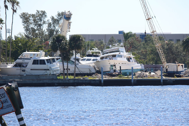
We had read and heard a lot about the
devastation Hurricane Ian did to the to the waterfront in Fort Myers and so
were not really looking forward to witnessing it first hand from Her Idea,
kind of like peeking while you like driving by an accident. Some things you
can’t unsee!
The
good news is there were lots of boats out on a beautiful Sunday that were
running up and down the waterways, which helped confirm the navigable channel.
The other wonderful thing is the Coast Guard has done an outstanding job in getting
most of the buoys and cans back in place, as most had been pulled off station
during the storm.
We
got through Fort Myers and will attach some pictures below so many months later
there still is a lot of boats and marinas in tough shape. Four miles eastbound
from downtown Fort Myers we pulled into
Tidewater Marina in North Fort Myers around 2 PM, had lunch, and cleaned up the
boat. There was a large Tiki Bar next to the Marina, so we of course had to go check
out their specialty Rum drinks, which were pretty good. The Tiki bar had a pool
on the side of the channel which you overlooked from the bar, so you can only
imagine what that crowd was like at 4 PM on a Sunday afternoon😊
We
got back to the boat, we cooked dinner on the grill and had an early night as the
next day we had 60-mile day and 4 locks.
Monday,
January 30,2023 Travel Day # 97 Sweetwater Landing, Fort Myers To Roland and Mary Anne Martin Marina, Clewiston
FL. Total Distance 59 Miles, Total Time 9.5 Hours
We
were unsure how long it would take to get through the locks and we had 4 of
them on this leg. If each took an hour in each lock which is common, and we had
to cover 60 miles at 9 MPH it could be a 10.5-hour day. Therefore, we started
out at 7:30 AM on a very foggy morning hoping we would arrive in Clewiston before 5:30 PM! One
mile from the Marina was our first lock. When we arrived and I called the Lock
Master he would not allow us to lock through because of the fog. He said he needed
to have visibility of the entire lock to put boats through. The lock is only
400 feet long so the fact the Lockmaster couldn’t see the end lock which is a good
indicator of how poor the visibility was. We had to wait 45 minutes just doing
circles until he gave us the green light to enter. The fog had lifted a little by the
time we locked through but it was still low visibility. It was 10 AM before we had enough
light to see a ½ mile and by 10:30 the sun was out and the fog burnt
off fully.
The
next lock was quick, and when we went through our ETA was to arrive in
Clewiston at 3:30 PM so we thought we had plenty of breathing room. That was
until we got to the third lock in Moore Haven.
We were informed by the Lockmaster that they had divers in the water,
and it would be a two-hour delay. Fortunately, they had a marina in Moore Haven
and so we made reservations there. Luckily, we got the last 45 feet of
available space on the wall, which is when your B Plan comes into play. This
was our backup, and I was glad we had it. To get to Clewiston by 5:30 PM we had
to depart Moore Haven by 3 PM. We had two hours of travel time (18 Miles) and
one last lock to get to Clewiston by 5:30 as sunset is around 5:45. We did not
want to dock in the dark.
Thankfully
we didn’t check into the slip that we reserved in Moore Haven but rather we floated
off the lock for an hour and a half. It paid off as the Lockmaster let us go
through by 3 PM. I think the Lockmaster felt sorry for us as I explained why we’re
trying to get to Clewiston, regardless it worked out for us. Once we got
through the lock we burnt extra diesel fuel and picked up our speed and was
able to get to the final lock in Clewiston by 4:30 and into the Marina before 5
PM. It was still a long 9.5-hour day but a bit more stressful than we planned,
well who plans on a stressful day right!. Between Moore Haven and Clewiston
there is NOTHING, the middle if nowhere. Therefore, once we went through the
lock we were committed. The marina in Clewiston is right next to the lock and had a Tiki Bar
which we happily check out once we got the boat cleaned up. This section of the
journey was very rural. This section is called the Caloosahatchee Canal and is a
narrow channel with hardly any marks. It was 60 miles that we just stayed in
the center of the OCWW and very few homes plenty of cows grazing the shoreline.
Moore Haven was the only town we passed through in the 60 miles.
The reason
we wanted to get to Clewiston is it is next to Lake Okeechobee. The Lake
crossing is 26.5 miles and it’s a big body of water. Normally in the early morning the winds are lower and it takes
a while for the waves to build so we wanted to get on the lake early. The only
concern was fog again was forecasted for the morning so we were hopefully be underway
by 9 AM. That was the plan. We ate on the boat after checking out the Tiki Bar and
went to bed early as it had been a long (stressful) day.
Okeechobee Waterway (OCWW)
Locks
Meredith Keeping us Against the Lock Wall
Doors Open, Time to Head Out
We got up at 7 and
sure enough there was a foggy haze on the water, so we had breakfast and did a
few chores and just waited for the fog to burn off. Unfortunately, we could not
see the lake from the marina, and it was less than a ½ a mile away. Things seemed to be clearing up so at 9 AM we
untied the boat and went through the first lock of the day and headed onto Lake
Okeechobee. The visibility was pretty good as we have 2-3 miles but it’s always
troubling to head into a fog bank, it’s just not something I feel really good about
doing. We turned our radar on
and said a few extra prayers!
Well, the good lord
came through and by 10 AM it was very clear. Also by then we had lost all sight
of land and we did not see any boats until we entered the lock on the other side
of the lake at the Port Mayaca Lock. We didn’t have any dolphins and very few
marks. Once you got 3 miles into the lake the marks were 7 miles apart, which
of course you can’t see that far. So, we had to rely on our courses that we had
developed the night before. We have
three different navigation aids that we use on the boat. We have a Garman Chart
Plotter, Navionics on an iPad, and Aqua Maps software on an Android Tablet. For
this crossing all three-applications agreed on the route, so we were confident
we were headed in the right direction.
Of course, it is always nice when the land shows up on the horizon. We
just followed the three magenta lines and had a very safe crossing.
We made it across in 3
hours and went through the Port Mayaca Lock just after noontime. The wind
was light and there was a very light chop on the lake and for the third day in
a row the temperatures were in the mid to high 70’s, just perfect. Once you depart
Lake Okeechobee on the eastern side, you enter the St Lucie Canal which will
take us to St Lucie and onto Stuart. 10-miles east of the lock we pulled into
Indiantown Marina for the night. Once again this entire waterway (OCWW) is
extremely rural, there were very few towns and an occasional marina, but very
few. Indiantown Marina was an interesting spot safe to say a step back in time.
The woman who runs it was extremely helpful and she made room for us. They were
full and I had been calling her every day for a week and finally she said call
me Tuesday and Il see what I could do. Plan B was to anchor 5 miles east, which
would have been a good back up. Tuesday Morning she gave us the green light.
She allowed us to stay on the fuel dock which was very kind of her. There was
nothing at the marina, so we had dinner and just chilled.
.
Crossing Lake Okeechobee
Wednesday,
February 1, 2023 Travel Day # 99, Indiantown Marina Indiantown FL to Pirates
Cove Resort, Stuart FL. Total Distance 30 Miles, Total Time 4.5 Hours 1 Locks
We
had a relatively easy day on Wednesday, only 30 miles, one lock and two bridges
that we had to have raised. One bridge is in Stuart which is on a fixed
schedule opening which was on the hour and half hour so had to time our arrival
accordingly. At Indiantown Marina we
were at the Fuel dock and had to slip out between two 50-foot sail boats and we
did so before any of the crew were up to assist our departure. It is always
best when getting in and out of a tight slip to have your neighbors around to
assist. Just feels better (unless you bump into them)! Meredith did an amazing
job getting us off the dock and we slipped out without issue. Bow and Stern
thrusters are a captain’s best friend, sure does making docking easier. We were
underway around 8:30 AM and had a pleasant fog free morning ride, clear skies,
and very little wind. We had a Railroad
bridge that we had have raised within a half mile once we re-entered the St Lucie
Canal. We then had a 10 mile ride to the last lock of the waterway which was
the St Lucie Lock. This lock dropped us down 13 feet and is the largest/highest
lock on the OCWW. The canal until we got to the lock was still remote. Once we
went through the lock the canal became more populated. Also, we saw more
recreational boats, folks fishing and just cruising the river. I ‘m pretty sure
folks don’t want to hassle going through the locks and stay on the eastern side
of the lock. Once you go through the lock you enter the St Lucie River, which
we took all the way to Pirates Cove in Stuart. There are three bridges that
cross the St Lucie River in the narrows between the North and South Fork. This
is kind of a bottleneck area as the clearance of the RR bridge is only five
feet so there is always a backup of boats jockeying into position. We had to
time our arrival so catch the 11:30 AM opening, which we did. The other two
bridges had 50-foot clearance, so we had no issues there. We had 8 boats pass
east and west bound for the 11:30 opening.
Three
miles north of Pirates Cove, which is in Manatee Pocket, we travelled through
our third “Hells Gate” since being on The Loop. When we passed through the
tides and current were fine and we experienced no issue. We arrived at Pirates
Cove around 12:30 and tied up to the fuel dock so we could fill our tanks and figure
out our slip arrangements for the month. As it turned out the slip they had assigned
us would not work. They insisted we try the slip, which we did, but the problem
was , we could not get off the boat. That would certainly be an issue. The dock
hands worked with us we ended up in a terrific location right at the main dock.
Oh,
and like our location in Sandestin, we have a Tiki Bar at the end of our dock,
oh my, more Rum Punches!
Pirates
Cove seems to be in a terrific location, we have a half dozen restaurants
within a 10-minute walk. The marina has mostly sport fishing boats several that
are beautiful, Vikings, and Posts, just stunning boats. The Georges have been
incredible generous and given us one of their cars for the month, so we have mobility,
and will be able to get around hopefully visiting some friends while we are
here. Thank you Cliff and Laura! We actually celebrated our 43rd wedding
anniversary with them last night and spent the night at their home here in
Stuart. A fun night and it’s just the beginning. For all of you that know Cliff
he has a month of fun planned for us. Its going to be an enjoyable, fun month
and blog free.
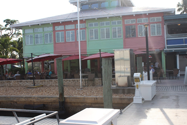
Pirates Cove
Our Slip for the Month
Some of our Neighbors
Celebrating our 44th Anniversary with The Georges
Our
plan from here is to restart Our Loop on March 1st and then spend the next
three months (March April & May)
getting back to Maine hopefully in early June. Pirates Cove is located only a
mile west of the Indian River which is where we will pick up the Atlantic Intracoastal
Waterway (AICW) at Mile 998 and take a left and head north to Norfolk VA. at
mile 0.
Fair
winds








.jpeg)
.jpeg)






Congrats on your successful trip from NW to SE Florida!! Great job navigating the weather, locks, bridges and dangerous Tiki Bars along the voyage! Enjoy your R&R at Pirates Cove…
ReplyDeleteTom & Annie
Wow! Sounds exciting for sure!! Enjoy your time in Stuart!! Hi to Meredith.
ReplyDeleteThis is Carol Lovett
DeleteWelcome back to the right side! Love your blog… you are a great writer!
ReplyDeleteEnjoy Stuart! My parents had a condo in Vero Brach… great area.
Have a great month! Happy Anniversary!
Lorin
PJ and Suzy, nice post, enjoy the month in Stuart FL and then the 90 push to home! Stay safe and have fun.
ReplyDeleteWhat a wonderful trip since 29 May! We’ve enjoyed being along with you through this blog. We’ve learned a lot about sailing that we had never known! Enjoy your month on “dry land”.
ReplyDeleteHappy to hear that you survived the Intercoastal with all the locks and bridges. It must have been a bit of a nail biter. It would have been for me.Hope you got my phone call on your Anniversary. Bless you both and many more. Hope to get a chance to drive over to Stuart for another quick visit. I'll call for dates later. Hugs and Best Wishes. Pat
ReplyDeleteNot sure when you will be passing through the North Myrtle Beach / Little River SC area, but Donna and I are down there through the month of March leaving around Easter. We would love to see you guys for a cocktail if it can work out. Bruce Akins
ReplyDelete